

France Braces for Contrasted Early November Weather: Dry North, Rainy South
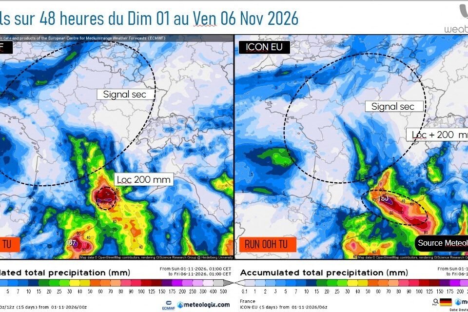
The first week of November 2026 is shaping up to be a study in contrasts across France. A powerful anticyclone anchored north of the British Isles is holding much of the country under a cool, mostly dry regime, while a developing depression over Spain threatens to bring significant rain to the Mediterranean coast. According to meteorologist and oceanographer Yann Amice, founder of Weather’n’co and speaking to actu.fr, the country should expect morning frosts, brisk coastal winds, and the potential for locally intense rainfall later in the week.
| Date | Expected conditions | Main impacts |
|---|---|---|
| Monday, Nov. 2 | Frosty morning, cloudy skies in the north, weak rain from Brittany to Hauts-de-France | Local lows near -1 °C to -2 °C; gusts up to 70 km/h on Channel coasts |
| Tuesday, Nov. 3 | Calm, dry, and cool under the anticyclone | Limited instability possible near the Gulf of Gascony |
| Wednesday, Nov. 4 | Rain returns to the Mediterranean coast | Moist south-easterly winds; precipitation strengthening overnight |
| Thursday, Nov. 5 | Persistent, locally heavy rain in the south | Possible local totals up to 200 mm; runoff and rapid river response |
| Friday, Nov. 6 | Gradual improvement across most of France | North and west remain dry; water-resource monitoring advised |
A Split Weather Pattern Takes Shape Across France
The dominant feature early in the week is a strong anticyclone with pressure exceeding 1040 hPa, positioned north of the British Isles. This high-pressure system is keeping a lid on Atlantic disturbances over much of northern and central France, resulting in generally dry weather. However, dry does not necessarily mean sunny. A weak disturbance is expected to sweep across northern France on Monday, bringing limited cloudiness and light rain from Brittany and Normandy through to Hauts-de-France.
Farther south, the outlook changes markedly. A depression is forecast to deepen over Spain by midweek, gradually pushing the anticyclone toward Central Europe. That shift will open the door for south-easterly winds to transport moisture from the Mediterranean toward the French coast, setting the stage for a wetter spell in the south-eastern half of the country.
Monday, November 2: Morning Frosts and Gusty Coastal Winds
The week will begin on a chilly note. Météo-France expects minimum temperatures generally between 0 °C and 4 °C across most of the country on Monday, with locally colder readings of -1 °C to -2 °C in sheltered parts of central and eastern France. Patchy white frosts are therefore likely at daybreak.
Northern and north-western regions will wake to heavily overcast skies. A weakly active disturbance should deliver light rain from Brittany and Normandy to the Hauts-de-France region. As the day progresses, precipitation should taper off, though cloud cover will linger from the Pays de la Loire through Île-de-France and into the north-east.
Wind will also be a factor. Gusts between 50 km/h and 70 km/h are anticipated along the Channel coasts, as well as in areas exposed to the mistral and tramontane. By contrast, the South-West and the Mediterranean rim should see brighter spells. Daytime highs are forecast between 10 °C and 15 °C for most areas, climbing to 16 °C to 19 °C near the Mediterranean.
Tuesday, November 3: Calm but Chilly Under the Anticyclone
Tuesday should remain relatively tranquil as the anticyclone north of the British Isles continues to act as a barrier against incoming disturbances. Yann Amice describes the flow as an east-to-north-east regime bringing relatively pleasant but cooler weather.
Some cloud cover and isolated light rain may linger near the English Channel. Additionally, a pocket of cold air at roughly 5,500 metres altitude between the Gulf of Gascony and western France could generate limited instability, though the meteorologist expects no major deterioration at this stage.
Wednesday, November 4: Rain Returns to the Mediterranean Coast
Wednesday marks the turning point for southern France. As the depression strengthens over Spain and the anticyclone drifts toward Central Europe, south-easterly winds will begin pushing humid Mediterranean air toward the French shoreline.
The first rains should develop along the Mediterranean coast on Wednesday, intensifying overnight into Thursday. Initially, precipitation may remain moderate, but it could grow stronger as the Spanish depression becomes better organised.
Thursday, November 5: Potential for Locally Intense Rainfall
Thursday is the day to watch in Mediterranean regions. When the moist air arriving from the sea meets the reliefs between the Pyrénées-Orientales and the Mediterranean mountain ranges, rainfall could become sustained and heavy.
The two main weather models reviewed by Yann Amice point to local accumulations potentially reaching 200 mm over the course of the episode. That equals 200 litres of water per square metre, enough to produce significant runoff and rapid responses in some rivers and streams.
The still-warm Mediterranean Sea for the season adds another layer of concern, as it acts as a reserve of moisture that could feed the precipitation. Amice notes that localised totals above 200 mm cannot be ruled out, although uncertainty remains high regarding exactly where the heaviest rain will fall. The precise position of the depression over Spain and the orientation of winds aloft will determine the final outcome, so forecasters urge residents to monitor updated bulletins.

Friday, November 6: Gradual Improvement, but Not Everywhere
After the potentially very rainy episode, conditions should begin to improve on Friday. Rain is expected to ease along the Mediterranean coast during the morning, followed by calmer weather across much of the country.
However, the northern and western halves of France may see little relief. “The signal remains dry across a large part of the north and west,” Amice observes. That lingering dry spell could compound pressure on water reserves in areas already facing fragile supplies, making water-resource monitoring a priority in the coming weeks.
Looking Ahead: Possible New Degradation Around November 8
Any respite may be brief. A new depression is expected to approach from the Atlantic around November 8, with possible effects on north-western France. It could also revive a south-easterly flow toward the Mediterranean regions. Looking further ahead, Amice is watching for another potentially significant rainfall episode around November 12 and 13, particularly over the Cévennes and the Mediterranean rim, though that trend remains highly uncertain at such long range.
Could the Polar Vortex Trigger a Cold Snap?
Recent discussions about a possible disruption of the polar vortex—the high-altitude wind circulation around the Arctic—have raised questions about whether it is behind the current weather pattern. Yann Amice confirms it is not. The present anticyclonic blocking is independent of any polar-vortex disturbance.
That said, a significant weakening of the polar vortex in the coming weeks could alter atmospheric circulation across the Northern Hemisphere and potentially favour cold-air outbreaks toward Europe. For now, however, there is no basis to predict a cold wave in France. Any consequences remain too uncertain to forecast reliably.
What Residents and Travellers Should Keep in Mind
The week ahead calls for regional vigilance. In the north and centre, the main concerns are early-season frosts and brisk coastal winds, which may affect sensitive crops and exposed travel routes. In the south, the focus shifts to heavy rain, localised flooding risks, and rapid river level rises, especially from Wednesday night through Thursday. Meanwhile, the persistent dry signal in the north-west means water restrictions and low reservoir levels could remain an issue even as the south grapples with excess water.
Forecasters emphasise that details—particularly the exact location of the heaviest Mediterranean rain—are still evolving. Checking updated forecasts from Météo-France and reliable news outlets such as actu.fr will be the best way to stay prepared as the week unfolds.
France’s early November weather is defined by division: a cool, dry north-west under a stubborn anticyclone, and a rain-threatened south-east facing the possibility of locally intense Mediterranean downpours. While the polar vortex is not driving the current pattern, its behaviour in the coming weeks could still influence temperatures later in the season. For now, the safest approach is to plan regionally, stay alert to official warnings, and expect the forecast to sharpen as each day arrives.
News, Science, Society, Government, Home, Travel, France, European Weather, Early November 2026, Meteorology, Anticyclone, Mediterranean Rainfall, Frost Risk, Yann Amice, Weather’n’co, Météo-France, Actu.fr, Flood Risk, Drought Concerns, Public Safety