
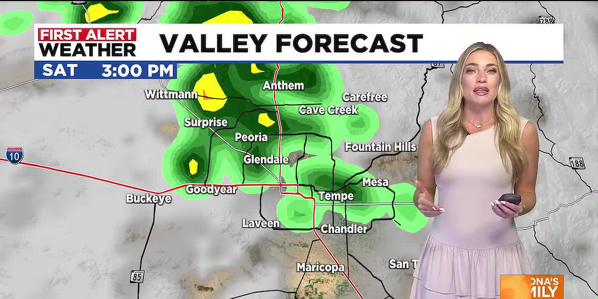

First Alert Weather: Tropical Moisture Brings Storms, High Winds, and Sharp Cool-Down to Arizona
The Phoenix metropolitan area is bracing for a dramatic weather shift this weekend as a surge of tropical moisture, enhanced by the remnants of Tropical Storm Rachel, collides with an approaching upper-level low pressure system. The National Weather Service has declared First Alert Days for Saturday, Sunday, and Monday, signaling a multi-hazard event that includes widespread thunderstorms, damaging wind gusts, localized flash flooding, and a temperature plunge of more than 20 degrees.
For a region still shaking off a stretch of triple-digit heat, the change arrives with whiplash speed. Friday afternoon highs near 103°F will give way to daytime temperatures struggling to reach the low 80s by Monday — a rare mid-October cool snap that will feel more like early autumn than late summer.
Tropical Connection: Rachel’s Remnants Fuel the Pattern
The primary moisture source is Tropical Storm Rachel, tracking northward along the western coast of Mexico and the Baja California peninsula. While the storm’s center is forecast to remain well southwest of Arizona, its expansive moisture plume will stream northeastward across the Desert Southwest, providing abundant fuel for thunderstorm development.
Meteorologists note that early to mid-October is a climatologically favored window for tropical remnants to influence Arizona weather. The eastern Pacific hurricane season remains active through November, and mid-latitude troughs dipping southward can effectively “catch” tropical moisture and advect it into the region. Rachel’s interaction with an incoming upper-level low — a cold-core system diving south from the Pacific Northwest — creates a classic setup for widespread, sustained rainfall rather than isolated monsoon-style pops.
Key Impacts at a Glance
• Rainfall: Valley floors 0.25–0.75″; High Country 1–2″+
• Wind: Sunday gusts 40–50 mph Valley-wide; 60+ mph high terrain
• Temperatures: 103°F Friday → low 80s Monday (20°+ drop)
• Flood Risk: Flash Flood Watch N. Arizona; Urban flooding possible Valley
• Timeline: Peak storms Sat night–Sun; lingering showers Mon (Columbus Day)
Day-by-Day Breakdown: When Impacts Peak
Saturday: Increasing Storm Chances, Evening Intensification
Clouds thicken through the day Saturday as moisture deepens aloft. Morning hours remain mostly dry across the Valley, with only a 20% chance of isolated showers. By late afternoon and evening, however, storm coverage expands rapidly as daytime heating combines with strong lift ahead of the upper low. The 6–10 PM window carries a 60% storm probability, with the strongest cells capable of producing brief heavy rain, small hail, and outflow wind gusts to 40 mph.
High Country locations — including Flagstaff, Show Low, and the Mogollon Rim — see earlier onset and higher coverage. Rainfall totals of 1 to 2 inches are likely through Sunday night, prompting a Flood Watch from Saturday morning through late Sunday night for northern Arizona. Burn scar areas from recent wildfires are particularly vulnerable to debris flows.
Sunday: The Most Active Day — Wind and Rain Combine
Sunday presents the highest overall impact. Rachel’s closest approach occurs Saturday night into Sunday morning, maintaining a 40% storm chance through the day. But the headline hazard is wind. A tight pressure gradient between the departing low and building high pressure to the north will drive sustained south winds of 25–30 mph across the Valley, with gusts to 50 mph — strong enough to down tree limbs, toss unsecured patio furniture, and create hazardous crosswinds for high-profile vehicles on east-west roadways like I-10 and US-60.
A Wind Advisory is in effect Sunday for most of Arizona, including Maricopa, Pinal, and Pima counties. High Country gusts may exceed 60 mph above 6,000 feet. Blowing dust is possible in agricultural areas and open desert corridors, reducing visibility suddenly.
Monday (Columbus Day): Lingering Showers, Chill Persists
The upper low pivots directly overhead Monday, keeping skies cloudy and temperatures suppressed. Highs only reach the low 80s in Phoenix — roughly 15 degrees below the mid-October average. Scattered showers persist at a 30% clip, mainly morning through early afternoon. While severe weather risk diminishes, the cool, damp conditions will feel raw for outdoor events and travelers.
Flood Threat: Urban and Rural Concerns
Rainfall forecasts remain uncertain in exact placement, but model consensus points to 0.50–1.00 inch across the Phoenix metro through Monday, with locally higher amounts where training storms set up. Desert soils, hardened by months of heat, absorb water poorly — increasing runoff efficiency. Normally dry washes can flash-flood within minutes of heavy rain upstream, even if it’s not raining at your location.
In northern Arizona, the Flood Watch encompasses the Flagstaff area, Oak Creek Canyon, and the Verde River basin. Snow levels will hover around 8,500–9,000 feet, meaning most precipitation falls as rain on already saturated ground from earlier autumn storms. The Arizona Department of Transportation (ADOT) advises checking AZ511 for real-time road closures, particularly on SR-89A through Oak Creek and I-17 near the Mogollon Rim.
Wind Advisory Details: What to Secure Now
The Sunday Wind Advisory is not a formality. Southwesterly gusts of 45–50 mph are forecast for the Phoenix metro, with isolated 55 mph gusts possible near mountain passes and through the Gila River valley. Residents should take these steps by Saturday evening:
- Secure or store patio furniture, trampolines, shade sails, and lightweight decorations
- Check tree limbs overhanging roofs or driveways; consider preemptive trimming
- Close and latch all windows, especially on windward (south/west) sides of homes
- Avoid travel in high-profile vehicles (RVs, box trucks, trailers) during peak gusts 10 AM–6 PM
- Expect delays at Sky Harbor Airport; crosswind limits may restrict some operations
For context, a 50 mph gust exerts roughly 10–12 pounds per square foot of pressure on a flat surface — enough to turn a standard 10×10 canopy into an airborne hazard.
Temperature Roller Coaster: From Summer to Sweater Weather in 72 Hours
The thermal drop is the most jarring aspect for residents. After months of 100°F+ highs, the plunge to the low 80s Sunday and Monday — with overnight lows dipping into the upper 50s — will feel startling. Tuesday and Wednesday mornings may wake up to the 50s Valley-wide, the coolest readings since April.
| Date | Phoenix High | Phoenix Low | Flagstaff High | Key Weather |
|---|---|---|---|---|
| Friday | 103°F | 74°F | 72°F | Hot, dry, increasing clouds |
| Saturday | 91°F | 68°F | 64°F | PM storms likely (60%) |
| Sunday | 84°F | 62°F | 55°F | Windy, showers (40%) |
| Monday | 81°F | 59°F | 52°F | Cool, showers (30%) |
| Tuesday | 78°F | 56°F | 54°F | Mostly sunny, cool |
| Wednesday | 82°F | 57°F | 56°F | Sunny, gradual warming |
By late next week, a rebuilding ridge of high pressure returns highs to the mid-80s and low 90s — more typical for late October — but the brief taste of autumn will be a welcome reset for energy bills and outdoor plans.
Historical Context: How Rare Is This?
Mid-October tropical moisture events are not unprecedented, but they’re infrequent enough to catch newcomers off guard. Notable analogs include Hurricane Nora (1997), which brought 3–5 inches of rain to western Arizona, and Hurricane Rosa (2018), whose remnants triggered flash flooding in the Phoenix metro. Rachel’s track and moisture feed resemble Rosa, though with a stronger wind component due to the tighter pressure gradient from the upper low.
Climatologically, Phoenix averages just 0.58 inches of rain for the entire month of October. This single weekend could deliver a month’s worth — or more — in 48 hours.
Preparedness and Resources
Stay informed through official channels:
- National Weather Service Phoenix: weather.gov/phoenix — warnings, forecasts, radar
- AZFamily First Alert Weather App: Real-time alerts, interactive radar, hour-by-hour forecasts
- Maricopa County Emergency Management: ready.maricopa.gov — shelter info, sandbag locations
- ADOT Travel Information: az511.gov or dial 511 — road conditions, closures, cameras
- Flood Control District of Maricopa County: fcd.maricopa.gov — real-time rain/stream gauges
Report storm damage, flooding, or downed power lines to your local utility (APS, SRP) or non-emergency police line. For life-threatening emergencies, call 911.
This weekend’s system is a reminder that Arizona’s weather doesn’t follow a calendar. The monsoon may have officially ended September 30, but the atmosphere pays no attention to dates. Stay alert, stay prepared, and take the wind seriously — it’s often the most underrated hazard in these hybrid tropical-midlatitude events.
News, Weather, Arizona, Phoenix, Maricopa County, Tropical Storm Rachel, Flood Watch, Wind Advisory, First Alert Days, Columbus Day Weekend, Flash Flooding, High Wind Warning, Temperature Drop, Monsoon Season, Desert Southwest Weather, National Weather Service, AZFamily, KTVK, KPHO