

Severe Thunderstorm Alert Issued for Central Minnesota and Western Wisconsin This Afternoon
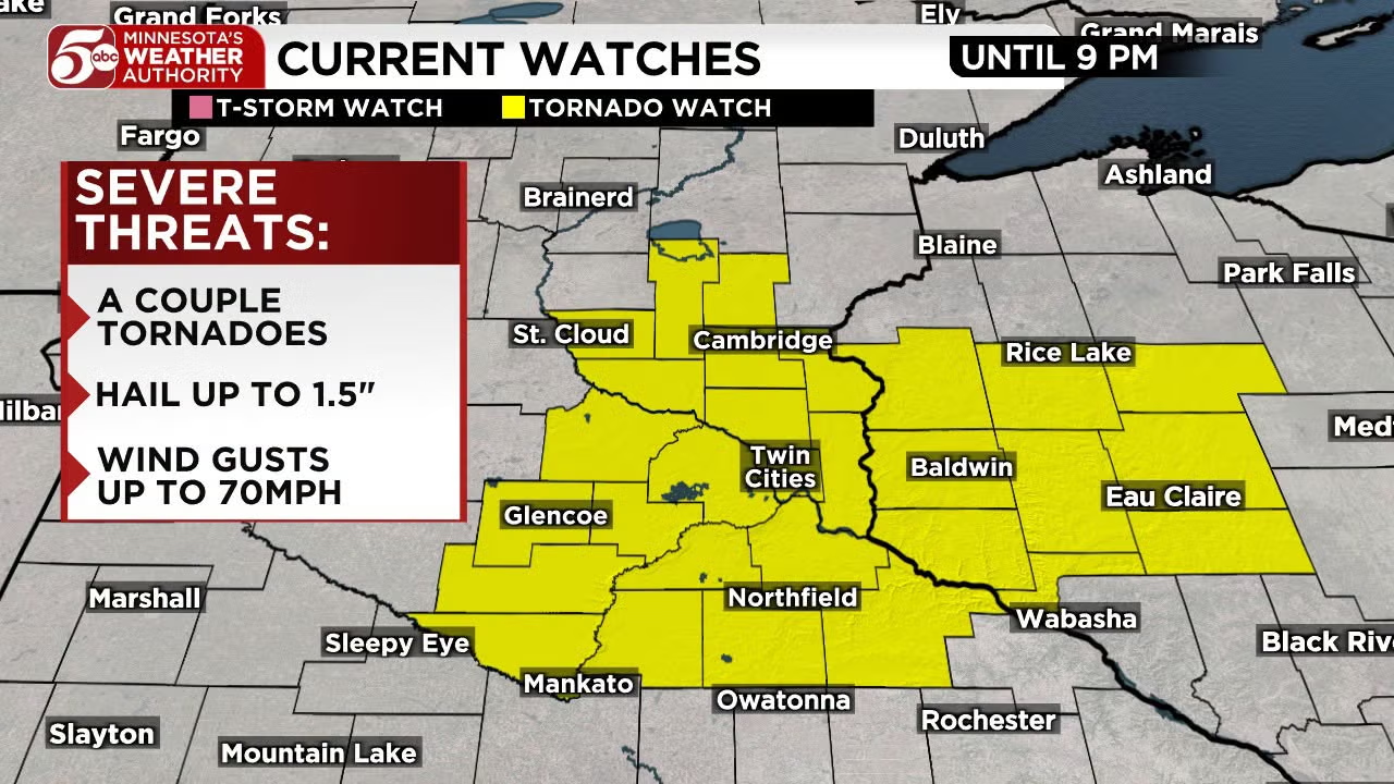
Minnesota’s Weather Authority has issued a weather alert for the potential of severe afternoon thunderstorms across central Minnesota, with the system expected to track eastward and reach western Wisconsin by the evening hours. The developing storms could disrupt the afternoon commute and after-school activities in the Twin Cities metro, bringing gusty winds, hail, heavy rain, frequent lightning, and the possibility of isolated tornadoes.
Forecasters emphasized that not every community will experience severe weather, but anyone with outdoor plans or travel scheduled for the late afternoon and evening should monitor conditions closely and be ready to seek shelter if warnings are issued.
Where the Storms Are Expected to Track
The storm system is forecast to move from west to east across central Minnesota during the afternoon. Initial activity is expected to develop west of the Twin Cities around midday before intensifying and pushing into the western metro area after 3 p.m. By evening, storms should spread into western Wisconsin.
Residents along major travel corridors and in west-central Minnesota communities should pay particular attention to updates as the line of storms advances.
Timing: When Severe Weather Could Reach the Twin Cities Metro
A line of showers and thunderstorms will develop to the west of the Twin Cities around midday. These storms are expected to intensify and move into the west metro area after 3 p.m., continuing through the metro during the afternoon and evening drive.
Because the timing overlaps with the end of the school day and many evening practices, games, and outdoor events, families and event organizers should have a backup plan in case conditions deteriorate quickly.
School Dismissal and Evening Activity Concerns
Storms moving through the metro during the afternoon and evening drive could coincide with after-school activities, sports practices, and other outdoor gatherings. Parents, coaches, and event staff are encouraged to monitor real-time radar and be prepared to delay or move activities indoors if lightning or damaging winds approach.
Primary Threats: Damaging Winds, Hail, Lightning, and Isolated Tornadoes
| Threat | Expected Impact |
|---|---|
| Damaging Winds | Gusts up to 60 MPH possible in stronger storms |
| Hail | Possible with any intense thunderstorm cell |
| Heavy Rain | Localized downpours could reduce visibility and cause ponding on roads |
| Frequent Lightning | Dangerous cloud-to-ground strikes likely with thunderstorm activity |
| Isolated Tornadoes | A strong or severe storm or two cannot be ruled out |
Meteorologists noted that while widespread severe weather is not guaranteed, any stronger storm that develops could produce damaging winds up to 60 MPH, hail, heavy rain, frequent lightning, and isolated tornadoes. The threat is highest during the peak heating of the afternoon and into the early evening.
How to Stay Safe During Afternoon and Evening Storms
- Keep a reliable method for receiving weather alerts, such as a mobile phone with emergency notifications enabled.
- If you are driving during the evening commute, allow extra travel time and be prepared for sudden reductions in visibility from heavy rain.
- Secure loose outdoor objects that could become airborne in gusty winds.
- Postpone or move indoor any after-school practices, sporting events, or outdoor gatherings if lightning or severe thunderstorm warnings are issued for your area.
- Seek shelter in a sturdy building immediately if a severe thunderstorm or tornado warning is issued for your location.
Where to Get Real-Time Weather Updates
Minnesota’s Weather Authority and local meteorologists are providing continuing coverage of the storm system. Viewers can track radar, watch live updates, and receive push notifications by downloading the station’s weather app.
Download the KSTP Weather App
The KSTP app is available for iPhone and Android devices through the major app stores. Downloading the app is the fastest way to get the latest severe weather alerts sent directly to your mobile device as conditions change throughout the afternoon and evening.
Bottom line: A severe thunderstorm alert is in effect for central Minnesota and western Wisconsin. Storms are expected to move through the Twin Cities metro during the afternoon and evening drive, with damaging winds up to 60 MPH, hail, heavy rain, frequent lightning, and isolated tornadoes possible. Stay alert, keep your phone charged, and have a shelter plan ready if you are outdoors or on the road later today.
Conditions can evolve quickly, and the timing or intensity of individual storms may change as new radar and satellite data become available. Residents are encouraged to rely on official National Weather Service warnings and local broadcast meteorologists for the most current information.
News, Science, Communities, Minnesota, Wisconsin, Twin Cities, Severe Thunderstorms, Weather Alerts, Public Safety, Emergency Preparedness, Informative, Urgent