

Jacksonville Weather Outlook: High Pressure Brings Sunshine and Warm Temperatures
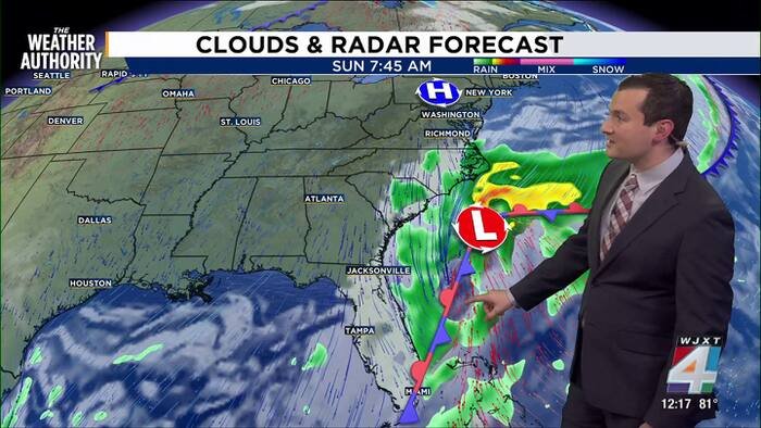
High pressure remains in control over northeastern Florida, delivering abundant sunshine and comfortable temperatures to Jacksonville and surrounding areas. The pattern, which has persisted for several days, keeps the region dry with highs in the mid‑80s and lows in the upper‑60s.
Today’s Forecast: Clear Skies and Light Northeasterly Breeze
Expect mostly sunny skies today with a high near 86 °F and a low around 68 °F. A gentle northeasterly wind will keep humidity at comfortable levels, and no rain or storms are anticipated.
Weekend Outlook: Front Arrives, Cooler Temps and Gusty Winds
A frontal system is expected to cross the area on Friday and stall to the south over the weekend. This will usher in cooler air, with highs dropping into the mid‑70s on Saturday and Sunday. The front also brings increased wind speeds, with gusts potentially reaching 40 mph, especially along the coast.
Coastal Hazards: Rough Surf, Tidal Flooding and Rip Current Risk
The stronger northeasterly flow associated with the front will elevate surf heights and increase the likelihood of tidal flooding in low‑lying areas. Beachgoers should exercise caution due to a heightened risk of rip currents.
Drought Monitor Shows Improvement After Recent Rainfall
The latest U.S. Drought Monitor indicates that several parts of northeastern Florida have been removed from drought categories, reflecting the substantial rainfall received over the past week. Conditions are now trending toward normal moisture levels.
Detailed Daily Outlook (Through Monday)
- TODAY: Mostly Sunny. High 86, Low 68.
- FRIDAY: Sun & Clouds. Breezy. High 87, Low 68.
- SATURDAY: Mostly Cloudy. Mainly Dry. Windy. High 75, Low 62.
- SUNDAY: Mostly Cloudy. Isolated Rain & Storms. Windy. High 73, Low 63.
- MONDAY: Partly Cloudy. Isolated Rain & Storms. Windy. High 77, Low 65.
Copyright 2026 by WJXT News4JAX – All rights reserved.
News, Science, Jacksonville Weather, Florida Weather, High Pressure System, Weekend Forecast, Coastal Hazards, Drought Monitor, Northeasterly Wind, Rip Current Risk